
When I first became interested in U.S. ZIP Codes, I thought comparing them across different states would be fairly straightforward. I expected to see different numbers and perhaps a few differences in formatting.
Instead, the comparison revealed how closely ZIP Codes are connected to geography, population, mail delivery, businesses, and everyday life.
The more ZIP Codes I compared, the more I realized that the five-digit numbers are part of a much larger system. They can provide useful clues about location, but they also have limitations that are important to understand.
Here are some of the things that stood out to me.
The First Surprise Was the Number Patterns
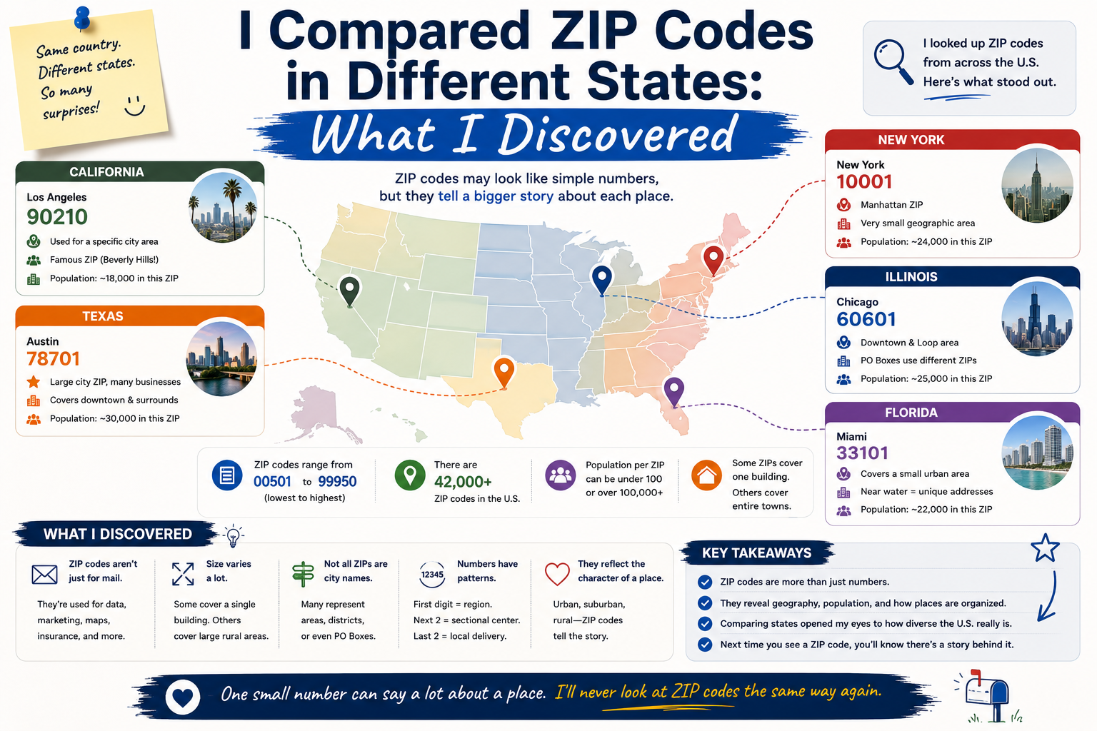
One of the easiest differences to notice is that ZIP Codes generally follow geographic patterns.
The first digit provides a broad regional indication, while subsequent digits make the location more specific.
This means ZIP Codes from different parts of the country can look quite different even before you know which city they represent.
For example, ZIP Codes beginning with 0 can be found in parts of the northeastern United States, while other regions use different leading digits.
This made me realize that ZIP Codes are not simply random numbers assigned independently to every location.
Different States Have Different ZIP Code Ranges
As I compared states, I noticed that their ZIP Code ranges can vary considerably.
Northeastern states tend to have lower-numbered ZIP Codes, while many western states have higher-numbered ones.
This broad pattern is useful when looking at a ZIP Code for the first time.
It does not tell me the exact city, but it can provide a general clue about which part of the United States the code belongs to.
I found that surprisingly interesting because a small five-digit number can contain a basic geographic signal.
Population Makes a Difference
Another thing I noticed was the relationship between ZIP Codes and population density.
Large metropolitan areas can have many ZIP Codes covering relatively compact geographic areas.
In less densely populated regions, a ZIP Code may cover a much larger geographic area.
This makes sense when considering how postal delivery systems need to serve different communities.
A dense urban area may require numerous delivery routes, while a rural area can have fewer addresses spread across a larger region.
State Borders Do Not Tell the Whole Story
I initially assumed that ZIP Code boundaries would closely follow state and city boundaries.
That turned out to be an oversimplification.
Postal geography does not always correspond perfectly with political or municipal boundaries.
A ZIP Code is primarily connected to postal delivery rather than being designed as a political boundary.
This distinction became especially important when I compared ZIP Codes in cities located near state borders.
The postal information associated with an address can sometimes look different from what I might expect based solely on a map.
Some Cities Have an Impressive Number of ZIP Codes
Comparing larger cities with smaller communities was another interesting experience.
Major metropolitan areas can have numerous ZIP Codes, sometimes covering different neighborhoods and business districts.
Smaller communities may have far fewer.
This difference illustrates how the ZIP Code system adapts to the needs of different populations.
It also explains why searching only for a city name may not always be enough to identify a specific ZIP Code.
ZIP Codes Are Useful for More Than Mail
Before comparing ZIP Codes, I mostly associated them with letters and packages.
My research changed that perspective.
ZIP Codes are frequently used in ecommerce, address verification, geographic analysis, marketing, delivery planning, and online forms.
When a website asks for a ZIP Code, it may be using that information for several purposes beyond simply displaying an address.
For businesses, ZIP Code information can also help identify service areas and understand where customers are located.
The Same State Can Have Very Different ZIP Code Environments
Another interesting discovery was that ZIP Codes within the same state can represent very different types of communities.
One ZIP Code might cover a dense urban neighborhood, while another could represent a rural area with a much lower population density.
This means that simply knowing a state does not provide enough information about a ZIP Code.
The local city, county, geography, and postal characteristics can all matter.
I Became More Careful About ZIP Code Data
While comparing different locations, I also realized that ZIP Code information should come from reliable sources.
A database may list a city or county association differently from another source because postal data and geographic classifications are not always identical.
For casual searches, this may not be a major concern.
For business operations, shipping, address verification, or other important purposes, accurate and current data becomes much more valuable.
I now pay attention to where ZIP Code information comes from rather than assuming that every online database is equally reliable.
ZIP Codes and Time Zones Can Be Connected
Another interesting detail I noticed was that ZIP Code information can sometimes be associated with a time zone.
This can be useful for businesses and applications that need to understand a customer’s approximate geographic location.
However, ZIP Codes should not be treated as perfect geographic coordinates.
They are postal identifiers, and their relationship with geography can be more complicated than a simple point on a map.
Comparing States Changed How I View ZIP Codes
Before this comparison, I thought of ZIP Codes as basic administrative information that I entered into forms without thinking.
Now I see them as part of a sophisticated system connecting geography and logistics.
The differences between states reflect the country’s enormous size and variety.
Urban areas, rural communities, coastal regions, inland cities, and rapidly growing metropolitan areas all interact with the postal system in different ways.
The ZIP Code system helps organize that complexity into a format that people and computer systems can easily use.
Final Thoughts
Comparing ZIP Codes across different U.S. states was more educational than I expected.
I discovered that ZIP Codes have broad geographic patterns, that different states contain different ranges, and that population density can influence how many ZIP Codes are needed in a particular area.
I also learned that postal boundaries do not necessarily match city or state boundaries perfectly.
Most importantly, I stopped thinking of ZIP Codes as random five-digit numbers.
They are practical identifiers that help connect addresses with postal services, businesses, technology, and geographic information.
The experience also taught me to verify important ZIP Code information rather than relying on assumptions.
My biggest takeaway is that every ZIP Code tells a small part of a much larger geographic story. Comparing them across states made me realize just how much organization is hidden behind those five simple digits.